
Long Range Weather Forecast Discussion May 26-June 9
1609 PM Fri. May 23, 2025
May 36-30: The pattern will feature a couple of upper lows. One will approach the Southwest and the other over the north-central states.
The western upper low will slow the momentum of a ridge building into the West. The system will cause heavy rain from the central Rockies to the northern and central Plains as its moves through the West early next week. An unsettled pattern is expected across the South and Southeast bringing the threat of heavy rain and flash flooding for the South. This will be caused by a stalled boundary interacting with a moist gulf flow. Rain will spread from the Plains to the Mid-Atlantic in the mid-to-late next week.
May 31-June 4: A ridge is forecast over the western and central states with a trough in the East. The ECMWF has an upper low over the eastern Pacific and the Southeast.
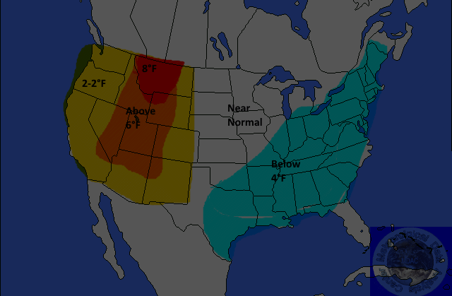
TEMPERATURES
 <
<
Yellow-2-4°F Above
Orange-4-6°F Above
Red-6-8°F
or Greater Above
Light Blue 2-4F Below
Medium Blue-4-6F Below
Dark Blue-6-8F or Great Below
Above-normal temperatures are forecast for the West. Anomalies are expected to be near 8°F in some locations. Below normal temperatures are forecast for eastern and southern Texas, the lower Mississippi Valley, portions of the Southeast, the Tennessee Valley, and the Midwest. Anomalies are expected to be near 4°F.
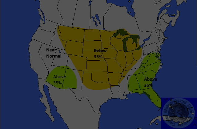
PRECIPITATION
Yellow 35%Below
Brown-35-45% Below
Dark Brown-45-55% Below
Light Green-30-35% Above
Medium Green-35-45% Above
Dark Green-45-55%Above
Below normal precipitation is forecast for the eastern and northern Rockies, parts of the southern and northern Plains, and eastward into the Great Lakes region. The probability of occurrence is near 35 percent. Above-normal precipitation is forecast for parts of the Southeast. The probability of occurrence is near 35 percent.
June 5-9: A nearly zonal flow with above normal heights are forecast across steh nation. The GFS has a trough across the northern states.
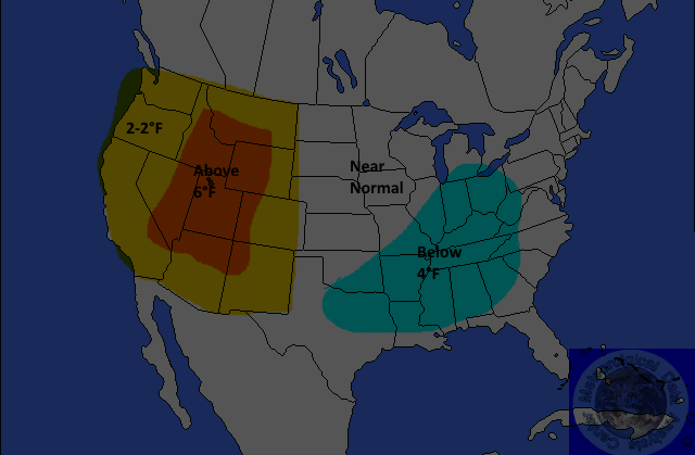
TEMPERATURES
Yellow-2-4°F Above
Orange-4-6°F Above
Red-6-8°F
or Greater Above
Light Blue 2-4F Below
Medium Blue-4-6F Below
Dark Blue-6-8F or Great Below
Above-normal temperatures are forecast for the Northwest to the northern Plains, parts of the Great Lakes region, a portion of the Ohio Valley, the Mid-Atlantic, and the Northeast. Anomalies are forecast to be near 6°F. Below-normal temperatures are forecast for the middle and upper Mississippi Valley to the Atlantic Coast. Anomalies are expected to be 4-6°F.
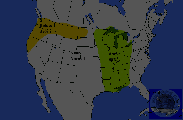
PRECIPITATION
Yellow 35%Below
Brown-35-45% Below
Dark Brown-45-55% Below
Light Green-30-35% Above
Medium Green-35-45% Above
Dark Green-45-55%Above