
Atmospheric patterns, 700 mb and 500 mb height anomalies, statistical data, ECMWF, and Canonical Correlation analysis, observed cases from past summers, sea surface temperatures were analyzed but the effect on the global circulation are expected to be minimal.
In the past month, neutral conditions continued, as indicated by near-normal sea surface temperatures in the east-central equatorial Pacific Ocean. The latest weekly Niño-3.4 index value was +0.4°C, with the westernmost (Niño-4) and easternmost (Niño-1+2) indices at +0.5°C and +1.0°C, respectively. The equatorial subsurface temperature index from 180°-100°W increased for the sixth consecutive month, with widespread, significantly above-normal subsurface temperatures across the equatorial Pacific. Westerly wind anomalies were observed over the western equatorial Pacific at low levels and were evident over the central and east-central Pacific at upper levels. Convection was near average on the equator near the Date Line and was suppressed around Indonesia.
The North American Multi-Model Ensemble average, including the NCEP CFSv2, favors a warm episode to form by next month and persist through Northern Hemisphere winter 2026-27. While confidence in the occurrence of a warm episode has increased since last month, there is still substantial uncertainty in the peak strength of the warm episode. The strongest El Niño events in the historical record are characterized by significant ocean-atmosphere coupling through the summer, and it remains to be seen whether this occurs in 2026.
The MJO is currently weak, disorganized, and stalled over the Indian Ocean. Still, model guidance shows it should resume slow eastward propagation with possible re‑amplification heading into late May and early June. The MJO became more disorganized over the past week due to interference from other tropical variability modes, such as enhanced convection stalled over the Indian Ocean, which was weakened by Rossby wave interference. A broad divergent (enhanced convection) signal has developed over the central Pacific, tied to a lower‑frequency background state (warming sea surface temperatures). Low‑level and upper‑level wind anomalies show the MJO signal is present but muted, with easterly/westerly anomaly patterns disrupted. Dynamical models (GEFS, ECMWF) show the MJO will resume eastward propagation across the Maritime Continent. Amplitude is expected to remain weak to moderate as it crosses the Maritime Continent. Re‑amplification is likely as it enters the Pacific in late May or early June, partly due to constructive interference with the low‑frequency background state (warming central Pacific sea surface temperatures).
The ECMWF monthly depicts a nearly zonal flow with above-normal heights across the nation. The SEAS5 gives a 70-100 percent chance of above-normal temperatures across the country. The C3S is similar. The CamSIPS depicted near normal heights across much of the country for July-August.
The ECMWF monthlies depict above-normal temperatures across the nation. The SEAS5 has a 50-100 percent chance of above normal temperatures across the country. The greatest chances are across the West and parts of the South. The C3S is similar. The CamSIPS has above normal temperatures for eth Four Corners, the Plains, into the Midwest, and parts of the Southeast.
TEMPERATURES
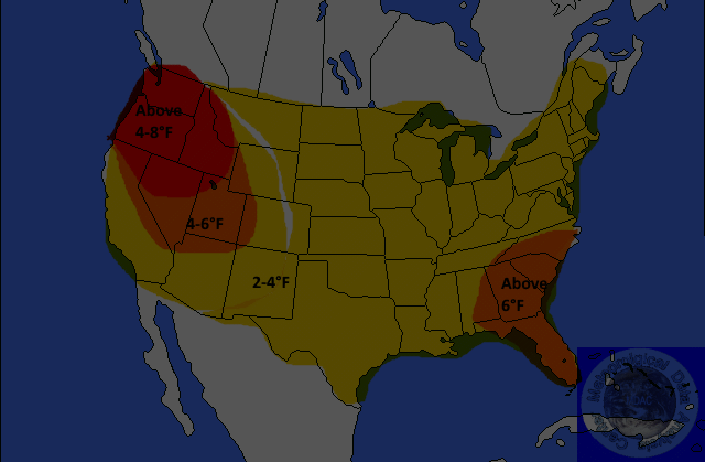
Yeloow-2-4°F
Orange-4-6°F
Red-6-8°F or Greater
Mediam Blue 4-6F Below
Dark Blue-6-8F or Great Below
Above normal temperatures are forecast for the country. Anomalies could be 4-8°F in some locations in the West and near 6°F in parts of the Southeast. The remainder of the nation is not expected to exceed normal climatology.
PRECIPITATION
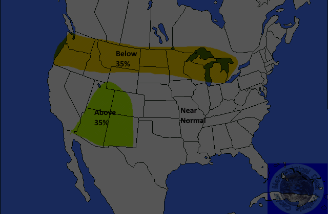
Yellow=-35%
Below
Brown-35-45% Below
Dark
Brown-45-55% Below
Light
Green-30-35% Above
Green-35-45% Above
Dark
Green-45-55%Above
Below-normal precipitation is forecast for most of the northern states. The probability of occurrence is near 35percent. Above-normal precipitation is forecast for most of the Four Corners. The probability of occurrence is 35 percent. The remainder of the nation is not expected to exceed normal climatology.
SEASONAL HEIGHT ANOMALIES

Jim Munley Jr.
http://www.jimmunleywx.com
Forecast Verification