
Atmospheric patterns, 700 MB and 500 MB height anomalies, statistical data, and various models such as the ECMWF monthly and weekly, NMME, IMME and the CFSv2, along with observed cases from past such months, data from 1895-2000 were used in this forecast.
In the past month, neutral conditions continued, as indicated by near-normal sea surface temperatures in the east-central equatorial Pacific Ocean. The latest weekly Niño-3.4 index value was +0.4°C, with the westernmost (Niño-4) and easternmost (Niño-1+2) indices at +0.5°C and +1.0°C, respectively. The equatorial subsurface temperature index from 180°-100°W increased for the sixth consecutive month, with widespread, significantly above-normal subsurface temperatures across the equatorial Pacific. Westerly wind anomalies were observed over the western equatorial Pacific at low levels and were evident over the central and east-central Pacific at upper levels. Convection was near average on the equator near the Date Line and was suppressed around Indonesia.
The North American Multi-Model Ensemble average, including the NCEP CFSv2, favors a warm episode to form by next month and persist through Northern Hemisphere winter 2026-27. While confidence in the occurrence of a warm episode has increased since last month, there is still substantial uncertainty in the peak strength of the warm episode. The strongest El Niño events in the historical record are characterized by significant ocean-atmosphere coupling through the summer, and it remains to be seen whether this occurs in 2026.
The MJO is currently weak, disorganized, and stalled over the Indian Ocean. Still, model guidance shows it should resume slow eastward propagation with possible re amplification heading into late May and early June. The MJO became more disorganized over the past week due to interference from other tropical variability modes, such as enhanced convection stalled over the Indian Ocean, which was weakened by Rossby wave interference. A broad divergent (enhanced convection) signal has developed over the central Pacific, tied to a lower frequency background state (warming sea surface temperatures). Low level and upper level wind anomalies show the MJO signal is present but muted, with easterly/westerly anomaly patterns disrupted. Dynamical models (GEFS, ECMWF) show the MJO will resume eastward propagation across the Maritime Continent. Amplitude is expected to remain weak to moderate as it crosses the Maritime Continent. Re amplification is likely as it enters the Pacific in late May/early June, partly due to constructive interference with the low frequency background state (warming central Pacific sea surface temperatures).
The ECMWF weeklies depict a trough across the Northwest and the Northeast for week 1. The flow flattens to more zonal thereafter. The CanSIPS and the C3S indicate a zonal flow and above normal heights. Subx indicates mixed signals.
The ECMWF weeklies depict below-normal temperatures for parts of the Southwest and most of the East for week 1. Above-normal temperatures are forecast across the nation thereafter. The CanSIPS depicts above-normal temperatures across the country. The C3S is similar. The Subx depicts above-normal temperatures in the West and below-normal temperatures in the East.
TEMPERATURES
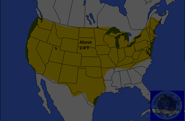
Yeloow-2-4°F
Orange-4-6°F
Red-6-8°F or Greater
Mediam Blue 4-6F Below
Dark Blue-6-8F or Great Below
Above-normal temperatures are forecast for most of the country. The exception will be parts of the Gulf Coast States and the Southeast. Anomalies are expected to be near 4°F. The remainder of the country is not expected to exceed normal climatology.
PRECIPITATION
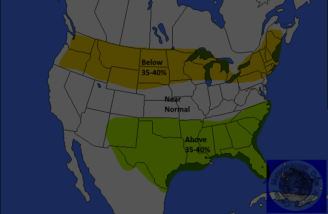
Yellow=-35%
Below
Brown-35-45% Below
Dark
Brown-45-55% Below
Light
Green-30-35% Above
Green-35-45% Above
Dark
Green-45-55%Above
Above-normal precipitation is forecast for most of the Northwest, eastward into the northern Mid-Atlantic and the Northeast. The probability of occurrence is nearly 35-40 percent. Above-normal precipitation is forecast for most of Arizona eastward across the Southeast. The probability of occurrence is up to 40 percent. The remainder of the nation is not expected to exceed normal climatology.
Jim Munley Jr.
http://www.jimmunleywx.com/jimmunleywx
MONTHLY HEIGHT ANOMALIES

Forecast Verification
Return To Long Range Forecasts Page
If you have any questions about, or any suggestions for this website, please feel free to either fill out our guestbook, or contact me at jamesmunley@verizon.net.