
Long Range Weather Forecast Discussion June 22-July 6
1442 PM EDT Fri. June 19, 2026
June 22-26: A quasi-zonal flow pattern is expected across the country with a trough across the Great Lakes and an upper ridge building over the Southwest.
A frontal boundary across the south-central states will result in additional heavy rain and thunderstorms from the central Plains to the South, and another area of heavy rainfall for the Northeast on Monday.
June 27-July 1: A zonal flow is forecast across the country with a broad ridge across the southern states.
A system tracks from the Mississippi Valley and the Midwest on Friday with rain and storms. This system moves eastward into the East Coast at the start of the period. Rain and storms will also be possible from the northern Rockies into parts of the South. A strong low will move through Canada and push a front east through the Great Lakes on Tuesday, reaching the East Coast by Wednesday, with rain and storms.
TEMPERATURES
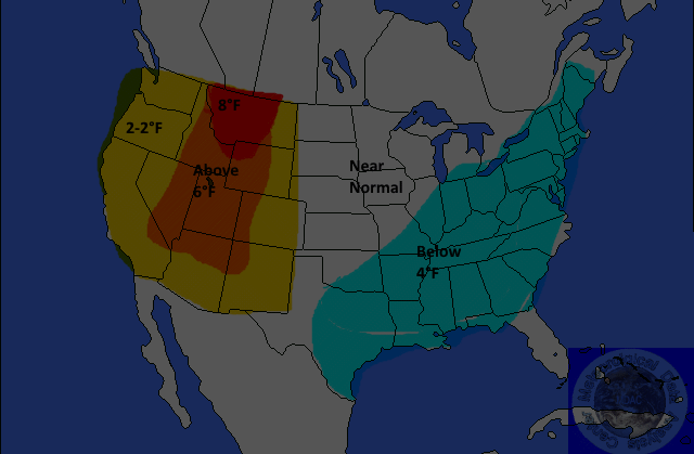
Yellow-2-4°F Above
Orange-4-6°F Above
Red-6-8°F
or Greater Above
Light Blue 2-4F Below
Medium Blue-4-6F Below
Dark Blue-6-8F or Great Below
Above-normal temperatures are forecast for most of the Southeast, the Gulf Coast States, the lower Mississippi Valley, the southern Plains, and the West. Anomalies are expected to be near 8°F in parts of the Rockies.
PRECIPITATION
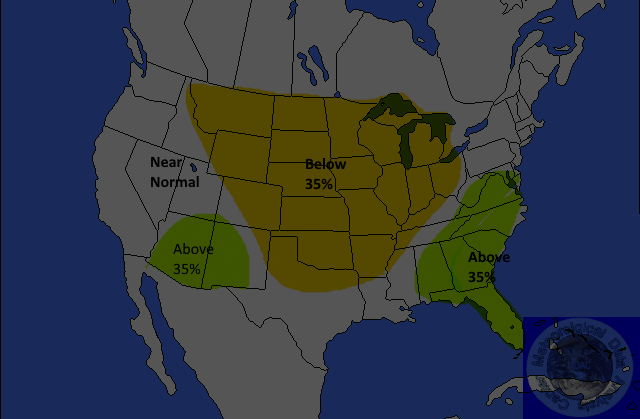
Yellow 35%Below
Brown-35-45% Below
Dark Brown-45-55% Below
Light Green-30-35% Above
Medium Green-35-45% Above
Dark Green-45-55%Above
Above normal precipitation is forecast for the northern Rockies eastward to the upper Mississippi Valley. The probability of occurrence is 35 percent. Below normal precipitation is forecast for the eastern Four Corners. The southern Plains to the Southeast. The probability of occurrence is 35 percent.
July 2-6: In general, expect little overall change in the pattern. A zonal flow remains in place. However, the GFS brings a trough into the West. The ensembles have a trough, ridge, and trough pattern across the country.
A ridge is forecast in the East with scattered showers and storms across the Southeast. Energy riding over the ridge will cause rain and storms from the Great Lakes to the Northeast.
TEMPERATURES
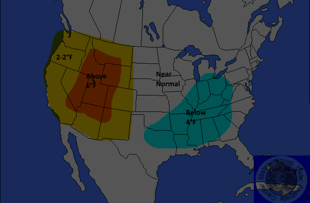
Yellow-2-4°F Above
Orange-4-6°F Above
Red-6-8°F
or Greater Above
Light Blue 2-4F Below
Medium Blue-4-6F Below
Dark Blue-6-8F or Great Below
Little change is expected in the temperature anomaly forecast from the previous period.
PRECIPITATION
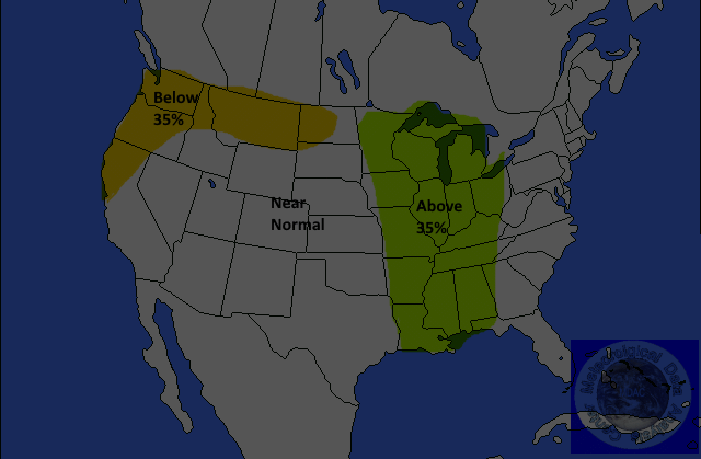
Yellow 35%Below
Brown-35-45% Below
Dark Brown-45-55% Below
Light Green-30-35% Above
Medium Green-35-45% Above
Dark Green-45-55%Above