
Atmospheric patterns, 700 MB and 500 MB height anomalies, statistical data, and various models such as the ECMWF monthly and weekly, NMME, IMME and the CFSv2, along with observed cases from past such months, data from 1895-2000 were used in this forecast.
During March, sea surface temperature anomalies continued to weaken across most of the equatorial Pacific Ocean. Sea surface temperature anomalies were lowest in the far eastern Pacific Ocean, with the latest weekly Niño-1+2 value at -0.1°C. Weekly sea surface temperature index values in the other Niño regions were between +0.9°C and +1.2°C. Below-average subsurface temperatures strengthened in the area-averaged index, reflecting the expansion of negative subsurface anomalies associated with an upwelling Kelvin wave. Low-level wind anomalies were easterly over the west-central equatorial Pacific, while upper-level wind anomalies were mostly near normal. Equatorial convection was slightly suppressed around the Date Line and was near average around Indonesia.
The most recent IRI plume indicates a transition to ENSO-neutral during spring 2024, with La Niña potentially developing during late summer.
Following a robust Madden-Julian Oscillation during March, it weakened during early to mid-April according to the RMM-based MJO index. However, the observed 200-hPa velocity potential anomaly field depicts a continued MJO signal with its enhanced phase rapidly shifting eastward over the Western Hemisphere during the past two weeks. As this remnant MJO constructively interferes with a low-frequency signal over eastern Africa and the western Indian Ocean, the GEFS and ECMWF ensemble mean feature an increase in anomalous upper-level divergence for these areas during late April. This is expected to result in a stronger and more coherent MJO heading into May.
The ECMWF weeklies depict an amplified pattern for week-1 and 2 with a trough in the West and a ridge in the East. In week-3 and 4, a trough is forecast in the East and the western Atlantic and a ridge in the West. The Subx ensembles means depict above-normal heights across the nation. The C3S is similar.
As for temperatures, the ECMWF weeklies coincide with the height anomalies fields. The Subx depict above-normal temperatures across much of the nation. The C3S depicts above normal precipitation for the central Rockies, the northern Plains, the upper Mississippi Valley, the central and southern Plains into the Midwest and parts of the Southeast.
TEMPERATURES
Yeloow-2-4°F
Orange-4-6°F
Red-6-8°F or Greater
Mediam Blue 4-6F Below
Dark Blue-6-8F or Great Below
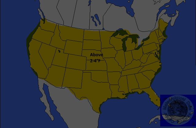
Below-normal temperatures are forecast for California into the Four Corners. Anomalies of up to 4-8°F are possible. Above-normal temperatures are forecast for the northern and eastern Plains to the Atlantic Coast. Anomalies of up to 8°F are expected. The remainder of the nation is not expected to exceed normal climatology.
PRECIPITATION
Yellow=-35%
Below
Brown-35-45% Below
Dark
Brown-45-55% Below
Light
Green-30-35% Above
Green-35-45% Above
Dark
Green-45-55%Above
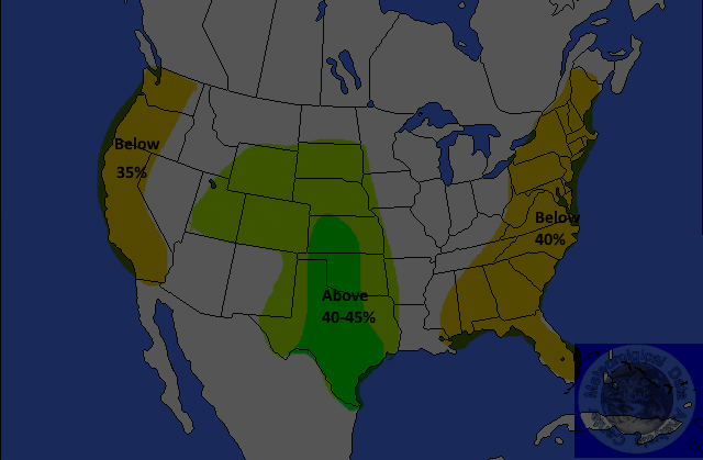
Above-normal precipitation is forecast for northern California, the Northwest eastward into the Great Lakes region. The probability of occurrence is nearly 40 percent. Below-normal precipitation is forecast for the southern Plains, a portion of the central and lower Mississippi Valley, most of the Gulf Coast States, the Southeast, the Mid-Atlantic and the Northeast. The probability of occurrence is nearly 40 percent. The remainder of the nation is not expected to exceed normal climatology.
Jim Munley Jr.
http://www.jimmunleywx.com/jimmunleywx
Forecast Verification